
Eastern Sierra Scenic Byway
Highway 395

Highway 395 is easily one of the most scenic drives in all of California, there's so much geology you'll see just by driving for a few hours along it. The highest point in the contiguous United States can be seen from it while a short drive from there will lead you to the lowest point in North America. You'll see lakes, dry lakes, desert, snow-capped mountains, extinct and dormant volcanoes, old mining operations, rivers, cool rock formations, waterfalls and more! Taking this drive during summer months can be very hot until you get to the upper elevations, During winter, it is typically very cold but visiting in spring and fall can be very nice temperature wise. Visiting in spring will still have snow capped mountains while visiting in fall will show you some beautiful fall colors.

This page is in order as you drive from Orange County, San Diego, and Los Angeles areas north to Lake Tahoe.
Depending on what time of day you leave, your GPS may take you through the 14 freeway or the 15 freeway which both connect to the 395. There is no straight line route from OC to the 395 because the San Gabriel Mountains stand in the way. You can go through Los Angeles County or Riverside and San Bernardino County.
The 15 freeway takes you through the Cajon Pass shortly before exiting onto the 395. By taking this route, you'll hit some traffic lights which will delay you a bit but you'll be taking the 395 from its southernmost point.
The 14 freeway takes you through Los Angeles County and spits you out farther up on the 395. This route will avoid all the stop and go traffic lights through Adelanto but you'll sit in heavy traffic on the freeways through LA depending on what time you go.


Red Rock Canyon (14 freeway route)
Accessibility: Easy
Access hours: Sunrise to Sunset
Features: Scenic desert cliffs, buttes, and colorful rock formations
The first scenic spot on your drive if you take Hwy 14, even just driving through makes for a cool sight but if you have the time, it's a cool stop that doesn't take very long. Of course you could spend the day or 2 here hiking, exploring, and camping. You'll see lots of red rocks and very interesting terrain! It's also a great spot for astrophotography. This is part of the state park system, for more info check out their website.

Randsburg
One of the richest gold mining towns in Southern California, Randsburg is considered a living ghost town since there is still a small population remaining. While the main mines have ceased operations, some smaller mining operations still exist.
This is a quick and easy stop as it's not far from Hwy 395 and you can see all the main sights just by driving through or stopping briefly. This stop is south of the Hwy 14 so it's only on your route if you do not take the 14.


Fossil Falls
A very unique geological feature formed by several of earths most powerful forces. This area is all old lava flows, all the ground you walk on here and are surrounded by once erupted from one of the several cinder cones that surround the area. This basaltic lava last flowed here as recently as 10,000 years ago and each eruption altered the flow of Owens River. After the most recent eruption, Owens River flowed through this area and carved out the basalt which formed this geologic oddity. Rocks that were carried downriver would get stuck as they fell over this waterfall and end up swirling around to form large holes as the water pushed against them. Over time, this water fall moved further back as it eroded away. Water no longer flows here so you can easily observe the forces of nature that created this very cool scene.
To access this site, it's an easy 1 mile drive down a dirt road that any car can make. Once parked, there is a trail that can be difficult to follow due to the terrain but it's easy to find your way back because you can use the large cinder cone for reference. There is also pretty good cell phone signal here so if you have any issues, you can use your phone. It's not advised to visit here during summer months as it can commonly get to 100° and there is no shade.
Fossil Falls
Cali, CA


Red Hill
One of the newest mountains in California, a 630 ft. tall volcano that the highway goes right past. If you exit for Fossil Falls, you will drive on the crushed maroon colored lava rock known as "scoria." This road will split off to the right for Fossil Falls but if you stay left, it will quickly take you to the backside of the cinder cone, you can drive right up to the bottom of it and walk around on it. There is a trail carved out that takes you up to the top as well.
Fossil Falls
CA

Dirty Socks Hot Springs
Located on Hwy 190 just 4.5 miles from Hwy 395, this large hot springs gets its name from its smell. There are many hot springs located along Hwy 395 but this is one of the easiest to access. It's worth checking out and taking a dip if you feel like it.
Dirty Socks Hot Springs
CA


Diaz Lake
A natural lake that was formed in 1872 after the Lone Pine Earthquake. This 7.4 earthquake caused a 20 ft. drop in elevation in Owens Valley, creating this lake which is fed by a spring. The 80 acre lake is now used for swimming, fishing, and boating. The campground surrounding the lake hosts tents and RV's. The lake can make for n easy stop to get out and stretch your legs, it also offers a good photo opportunity with a reflection of the Sierra Nevada Mountains.


Alabama Hills
Unique rock formations that you might recognize from several movies. Alabama Hills are a formation of rounded rocks and eroded hills situated at the base of the Sierra Nevada Mountains with Mt. Whitney looming over. These hills are just behind the town of Lone Pine where you can also visit the Museum of Western Film History to learn about the films produced there. Alabama Hills are located on BLM land which is free for day use. The area is accessed via maintained dirt roads which can be accessed with most vehicles.


Mt. Whitney Portal
The highest point in the Contiguous United States, Mt. Whitney is 14,505' above sea level. There are a few different ways to hike to the summit and it's not for beginners. However, even just visiting Mt. Whitney Portal which is where the trail starts is a great area to visit! A cafe and souvenir shop make for a great lunch stop. There's also a waterfall and small pond which you can fish. This area offers camping which is where many hikers spend a night or two in order to get acclimated before ascending to 14,000 ft.
While you cannot see Mt. Whitney's peak from here, it is easy to see from Lone Pine on a clear day. To view the peak, just stop by the ranger station in Lone Pine which sits right along Hwy 395 and there is a scope that aims right at the peak. It is difficult to pick out which peak Mt. Whitney is without using this because it does not appear taller compared to the other peaks around from this perspective.
The view from Mt. Whitney's summit


Manzanar Historical Site
A dark time in United States history when more than 110,000 Japanese Americans were imprisoned at 10 camps across the country. After the surprise attack on Pearl Harbor from Japan, Americans were terrified of more attacks. During this time, the United States was not as big of a super power as it is today so every step was made to protect the lives of Americans. One of these steps was unfortunately the incarceration of all people with Japanese origin living in America. This effort was to prevent spies from gaining knowledge about any military operations aimed at stopping the war. The Japanese Americans were enraged at Japan for the attack on Pearl Harbor and forcing us into war. Ultimately, thanks to the atomic bomb for ending the war and saving many lives, these people were eventually freed from these camps.
While these camps were nothing like the camps in Germany or Japan in which people were tortured and killed, it was still a very sad situation as these innocent people were pulled away from their lives that they've lived and known here in this country. Life at Manzanar was not easy going due to extreme weather conditions. Once the prisoners were released, they had to make new lives for themselves. Most were not able to go back to their houses or farms which they once owned.
Manzanar was mostly torn down in an effort to erase this from history but luckily in recent years, efforts have been made to restore it and educate people about what happened here.
5001 US-395
Independence, CA 93526


Ancient Bristlecone Pine Forest
Perched atop the mountains to the east of Highway 395 sits the oldest living things on the planet! The oldest tree of them all is known as Methuselah which is almost 5,000 years old. This tree is not marked in order to ensure it doesn't get vandalized. This grove of Ancient Bristlecone trees is located 23 miles from Big Pine and offers amazing views on the valley below. These Ancient Bristlecones really make for a stunning landscape at this high elevation. There are a few different hiking trails which will allow you to meander through the trees. There are many great photo opportunities here and is a great spot for astro photography. This area is closed during winter to due snow, check with the Forest Service for road conditions.
Ancient Bristlecone Pine Forest
White Mountain Rd
Bishop, CA 93514

Keough's Hot Springs
A hidden gem along the route, Keough's Hot Springs features a large swimming pool with natural warm spring water. There is also a shallow pool with natural spring fed water piped straight out of the ground that is around 104°. This hot springs pool was established in 1919 and is used by locals and tourists passing through the area. There are also campsites and tent cabins here that you can stay in. For more info, visit their website: Keough's Hot Springs
800 Keough Hot Springs Rd
Bishop, CA 93514
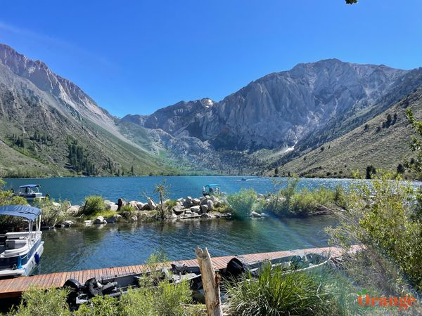


Convict Lake
A beautiful alpine lake with easy access, just a few miles from hwy 395. This is a beautiful spot to visit all year-round. In winter, the lake is typically frozen over and in the summer, it's a popular fishing and hiking area. The lake was named after a group of escaped prisoners from Carson City were found hiding out here in 1871. This natural lake is one of the deepest lakes in the Sierra Nevada, at 140 ft. What makes this lake really beautiful is the emerald color and the steep mountains surrounding it which were formed by magma and carved out by glaciers.
Convict Lake Resort
Mammoth Lakes, CA 93546

Owens River
At 183 miles long, the Owens River drains snowmelt from the Sierra Nevada Mountains, Inyo Mountains, and White Mountains. This slow moving, gentle river provides great fish habitat and life more many other animals along its route. It can be seen in many different spots along hwy 395 and the roads connecting to hwy 395. This river used to fill Owens Lakes until Los Angeles gained the rights to ths river and diverted it to supply the city of Los Angeles.
Hot Creek Hatchery Rd.
Mammoth Lakes, CA 93546


Hot Creek Geological site
This is easily one of the top spots to visit although few people actually do, located just a few miles from Hwy 395 on a gravel road. Hot Creek is located right along Owens River which adds to its beauty. Right next to the river are pools of turquoise colored water which is caused by the extreme temperatures of the water being pushed to the surface from magma just 3 miles below the surface. This is basically a miniature version of a geyser basin at Yellowstone but without the crowds. And just like Yellowstone, there are some fumaroles here as well. These fumaroles are basically steam vents from water being heated by magma below. The fumaroles vary from year to year so two different visits might reveal them in slightly different locations or different fumaroles might be more active than others. You can walk up to the fumaroles but watch your step, you can feel the steam coming out and also smell the sulphur.
Owens River used to be open to swimming in this area which was a fun experience. The river is snowmelt so it's cold when you first get in but it warms up quickly as you walk over areas where hot water is being pushed up. You're able to walk around and find the right temperature you want to hang out in. However, in 2006 the Forest Service closed the river to swimming due to hazardous geothermal activity with sudden bursts of scalding water. The turquoise pools have always been off limits, people that have slipped into them have been scalded to death.
Hot Creek Hatchery Rd.
Mammoth Lakes, CA 93546


Mammoth Lakes
The town of Mammoth Lakes has only 4 traffic lights but has everything you'd need in a town: gas stations, a grocery store, lots of restaurants, hotels, and shopping. It is an outdoors lovers paradise year-round with an amazing ski resort in the winter and mountain biking in the summer. There are lots of great hikes in the area and great fishing as well. This is a great spot to stay a couple nights during a road trip along Hwy 395 or can also be a great destination spot since there is so much to do here.


Devils Postpile & Rainbow Falls
Situated back behind the town of Mammoth Lakes is a valley called Red's Meadow. This valley is absolutely gorgeous and is only accessible by shuttle in order to keep vehicle traffic and noise down. The main attractions to this area are Rainbow Falls and Devils Postpile but there's also great camping, a general store, restaurant, and a river surrounded by beautiful meadows. The hikes to see the main sights in this valley are easy are range from half mile to about 3 miles. However, the Pacific Crest Trail and John Muir Trail also run through here so you will see some hikers with lots of gear on their packs.
")


Inyo Craters
A hidden gem located off a dirt road from Mammoths scenic route which takes you back to Hwy 395. To get here, you'll just need to drive along a dirt road for a few miles and hike in about 1 mile roundtrip. Inyo Craters are three separate craters where steam explosions occurred long ago and left these depressions where they have since filled with water. The water that sits in the main crater that you see first is turquoise and very pretty. It's worth stopping to check out and you'll likely be the only one here which makes it even more enjoyable.

")
")
")


June Lake
A beautiful lake with a small town and amazing ski resort, June Lake is great to visit year-round. In winter, the lake freezes over but in summer, the water is very clear and there's a nice beach to enter the water at.


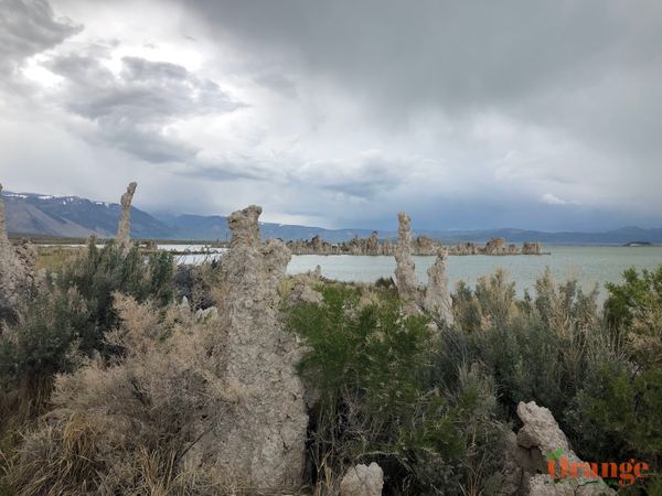

Mono Lake
A large saline lake with some cool natural formations. Mono Lake is visible from Hwy 395 but to get to the iconic tufa towers, you'll need to drive just a few miles from the highway with a portion on a graded gravel road. These tufa towers were formed underwater but as the lake level dropped, these columns became visible above the surface. Mono Lake is much saltier than the ocean and therefore, you are more buoyant on it, you can float very easily on it. The reason for its salinity is mostly due to the fact that there's no outlet, water flows into the lake but cannot flow out. There is also a volcanic island in the lake which you can only access by boat or kayak. This entire area is still geologically active and Paoha Island was formed from volcanic eruptions just 350 years ago. This island once housed a psychiatric ward where people were not able to escape, now days a visit to the island would show you some remnants of that. You can drive completely around this lake and it's common to see wild horses in the area. The best view of Mono Lake is from the viewpoint just a few miles farther up Hwy 395.


")


Bodie Ghost Town
One of the best preserved ghost towns in the country! In 1875, gold was discovered here while prospectors were digging a mine, just a few years later in 1877, Bodie was a full blown gold-mining town with a large operation. The population increased from less than 50 to about 8,000 and about 2,000 cabins. This gold mining boom was short lived, in 1891, the mine was hardly producing any more gold and people moved away. In 1892, a large fire broke out and burned most of the town. In 1932, another fire burned through the town. After this, only about 5% of the town remained. Small mining operations continued until 1942 which is when the town became abandoned. In 1962, the state park system took it over and is preserving the entire town in a state of arrested decay. Everything you see in the town is how it was left.
To get here, you'll need to take a gravel road for a few miles and pay a small entrance fee which helps preserve the town. For more info, visit Bodie Ghost Town